Route 66

Paul Jenkin

Well-known
Local time
1:53 PM
Joined
Nov 5, 2007
Messages
796
I'm flying a kite with this enquiry as nothing's been been organised or even discussed with my missus as yet........

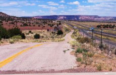
However, I've never been to the USA and I'm looking to find a reason for a bit of a road trip in 2013. Having seen books of photos of Route 66, I was wondering how practical it might be to organise a week or ten day trip to start off at one point, drive and fly home to the UK from another.

If anyone has information on this and any suggested itineraries / stopping off points / places of photographic / historical interest, I'd be extremely grateful.

Many thanks in anticipation.
 
You may know this from your books, but it's worth mentioning. Route 66 exists today only in short bits and pieces, here and there. Where it does exist, it is now the service road that runs alongside the interstate highways, such as highway 55 in Illinois, and highway 44 through Missouri (etc). Since Route 66 zigzagged, and the highways are straight, 66 will at one point be to the right of the highway, while at other places it's on the left. And at still other places, it's not there at all. In some places, it just comes to a stop in the middle of nowhere. All this tends to present a bit of a challenge!

From time to time, one sees a sign telling you where to turn for "Historic Route 66." And in towns, the streets that were once part of 66 as it passed through town are often marked with signs for "Historic Route 66 byway." Route 66 was basically cobbled together by selecting existing US routes (highways) that were along the intended route; and the city streets (byways) that were the most direct for getting through town. Here in St. Louis, these signs can be seen on Manchester Road, and Watson Road, for example.

If you want recommendations for books on Route 66, with specific driving directions, I could post a short list later today.
 
I've done parts of Rt 66, and though I'm sure people have their favourite parts, I like the western part of it (California, New Mexico etc). There are many Route 66 clubs that would be a great starting point for you ( http://www.historic66.com/internet/assoc/ ), so you can carefully choose the best spots for you for your 10 days. Please do bear in mind that much of what was (and what was on) Rt 66 is gone, but it does seem to be making a bit of a comeback in recent years.

Maybe starting in Santa Monica and head east? Start in Albuquerque?
 
If you only have 10 days (and given that jetlag is real), I don't think you can do the full length. As Vince suggested, maybe the (south-)western portion is a good option. Fly into Dallas (start Route 66 in Amarillo or OK City) and into Denver (start Route 66 in Amarillo or Albuquerque), and go west (and fly back from from L.A.)

You could also combine it with some side trips (e.g. Grand Canyon or Santa Fe).

Just to whet your appetite -- here is a photo from a Route 66 icon here in Arizona - Wigwam Motel in Holbrook :)


Holbrook, AZ - Wigwam Motel & 1959 Chevrolet Impala by nbg90455, on Flickr
 
Last edited:
Mike is right. It can't be done in 10 days.

I suggest you start in Southern California and work east - fly home from Dallas.

There are lots of motels etc along the way - you don't have to plan as much as you would think. I'd let the scenery dictate how fast you go (with your eye on the calendar regarding your flight home :)

It's a great trip - do it in the Fall or Spring, not summer.

Cheers,

Tom
 
In short....

In short....

I have heard there are terminations of Route 66, where you have to drive hundreds of mile (mostly out of your way) to reconnect with the next leg of 66.

It would be interesting to know how long the original Rt 66 was, and how many miles you now have to drive to get from the original starting point to the original end point.

I'm sure it must be in one of those books mentioned... Oh if I only had time to read.
 
I am with everyone else, Rt 66 has been broken up and mostly still exists in the short sections. I think the most scenic and interesting sections are between Nevada and Oklahoma City. My suggestion would be to fly into Las Vegas where you can rent a car and drive to Oklahoma City and back. You will get to see Hoover Dam, the Grand Canyon, Kingston AZ, Painted Desert, Petrified Forrest and much, much more. The car rental and air fair will be best from one destination and you will see things on the way back that you missed the first time.

RT-04.JPG


Here is a slide show of my cross country trip in my Suburban. We started East to West and also went through Utah and Colorado on the way back. I think you will get to see a lot in 10 days, just try to read up and look on the internet so you have a good idea of what you don't want to miss.

http://www.photos.3rdtrick.com/displayimage.php?album=16&pos=2

Sorry I did not have a rangefinder in 2001 but they are at least 'film' pictures...
Pete
 
In my reading somewhere in the past, I seem to recall there being a few discrepencies in some short areas as to the exact path of the original 66. The research of Route 66 is a pretty enjoyable endeavor in and of itself. Good luck, have fun.
 
Google can find more information than you need, or want.
There is a problem with the U.S. between Dallas and Los Angeles: Any state along that route could fill 10 days or 10 weeks or 10 years.
Okaloma seems to have some of the best preserved remnats of the small towns that once owed their economis to Route 66.
Tucumcari, NM is an interesting town that was on 66. The highway changed numbers and grew 2 lanes, but the feeling is the same.
Do NOT drive across southern Utah. You will hate leaving.
Late Fall/early Spring for sure.
Bon Voyage!

Wayne
Ps: If you are anywhere near Amarillo, TX, don't miss the Cadillacs!
 
Some books that i think will be useful:

"Route 66 The Mother Road" by Michael Wallis; 75th Anniversary edition, New York: St. martin's Griffin, 274pp. ISBN - 13: 978-0-312-28161-8

--This book has many photos, and also much discussion, history, and background info.

"The Complete Route 66 Lost and Found," by Russell A. Olsen. Voyageur Press, 320pp. ISBN 978-0-7603-3492-8

--Lots of photos, maps, driving directions, history. This one gives rather more space than most to "that which used to be."

Edit: Adding another book: "Ghost Towns of Route 66 "ext by Jim Hinckley, Photography by Kerrick James. Voyageur Press, 2011. ISBN 978-0-3843-8

--Photos, Historical info; directions on getting to 66 from the main highway.

If you happen to get to Springfield, MO, stay at the Rail Haven Motel, a Best Western and a Route 66 Motel with all the trimmings. I'll adda photo or two when I can.
 
Here's a bit of "The Mother Road" as it parallels I-40 west of Gallup, NM. A serious trip will take about two weeks from this point through California. Best of luck.
 

Attachments

  • Route 66-01A.jpg
    Route 66-01A.jpg
    77.8 KB · Views: 0
A few months ago I flew from Hong Kong to San Francisco for a 1 week roadtrip to the Southwest. If I could do it again I would begin my trip in Las Vegas and drive east or from New Mexico and drive west. I bought a whole mess of books on Route 66 and to my surprise much of the sites in the old b/w photos no longer exist. The only parts of Route 66 that had any sort of up keep are the parts in and near larger cities. The lonely stretches of road are pretty much battered and hard to drive on. The road sides are strewn with abandoned motels and service stations in phases of decay. I am into that sort of thing so it was a good experience for me. The Arizona desert is absolutely spectacular. The drive from Barstow to Oatman and then to Kingman was well worth the effort. You will find much of the surviving Route 66 landmarks have become tourist traps but they still have some charms.
 
" 3rdtrick" is the advice (or suggestion) I would consider,after my wife and I did pretty much this exact same route last March,(that was quite the snow storm also),car rental in Vegas is easy,the drop
off has to be seen to be believed.Oh yeah,and the Ford Focus we
rented did not seem to use gas!!!
Regards,Peter
 
I spent quite a bit of time on 66 for a photo project, and as has been discussed, in a great many places it's difficult to find the original route, and in so doing many of the icons of the past simply do not exist. Every time I return to one portion or another yet another one has been razed, painted, or covered with aluminium siding. My project involved photographing the entire route using infrared film - Kodak HIE before its demise - and then hand coloring the result for a 1940's post card feel. I have attempted to load three of the images here, but sometimes my uploading process goes awry. We'll see how this goes. At any rate, I would like to add that the state of Oklahoma left a great portion of the original route intact, and that's where I found a great many original sites, such as The Blue Whale in Catoosa, OK. The Closed Bridge is near Winona, AZ, and the Airstream and Wall Mural was in Barstow, CA.

It's a fun trip, but do it while you can. It keeps vanishing more and more every day.

Mark
 

Attachments

  • air stream&wall mural620.jpg
    air stream&wall mural620.jpg
    40.2 KB · Views: 0
  • Closed Bridge, Opus 2-620.jpg
    Closed Bridge, Opus 2-620.jpg
    43.2 KB · Views: 0
  • Blue Whale620.jpg
    Blue Whale620.jpg
    58.7 KB · Views: 0
Peter, Thank you for the support. I would also like to suggest Williams AZ as the first stop. It is close to the Grand Canyon and a good place to plan the rest of the trip. There is a section of Rt 66 that goes from Kingman AZ to Saligman that you can explore on the way.

Mark, The bridge photo is awesome.

Mike, Your Wigwam photo looks as if it came from 1959.

Paul, Don"t let us down. We want to hear about your trip and see the photos...
 
Back
Top Bottom